- Expanded version of a November 2011 posting. Updated with newly found pictures.
At least 100,000 Jews -- mostly women -- are expected to visitRachel's Tomb later this week. The burial site, located between Jerusalem and Bethlehem, has been venerated by Jews for centuries.
"And Rachel died, and was buried on the way to Efrat, which is Bethlehem. And Jacob set a pillar upon her grave: that is the pillar of Rachel's grave unto this day." Genesis 35:19-20
Saturday, the 11th of Cheshvan in the Hebrew calendar, is traditionally observed as Rachel's yahrzeit -- anniversary of her death some 3,600 years ago. Rachel's husband Jacob buried her on the side of the road, and according to the prophet Jeremiah, Rachel later wept as "her children" were exiled from the land of Israel. Rachel is considered a special figure for prayers and entreaties.
"30 men ('3 minyans') from a Jerusalem old age home praying for
the well-being of friends and donors and other brethren from the
House of Israel in the Diaspora next to the gravestone of Mother
Rachel of blessed memory." (Stephanie Comfort -- Jewish
Postcard Collection)
In 1622 the Ottoman governor of Jerusalem permitted Jews to build walls and a dome over the grave. [For historical background on Rachel's grave see Nadav Shragai.]
Rachel's Tomb (circa 1890-1900) (Credit: Library of Congress,
Detroit Publishing Co. photochrom color)
Click on the photos to enlarge.
Click on the captions to see the originals.
All photos are from the American Colony collection in the Library of Congress unless otherwise credited.
Visitors to Rachel's Tomb (circa 1910). Note the carriages in
the background and Jewish pilgrims under the tree (see
enlargement below). (Oregon State University collection)
For several hundred years a local Bedouin tribe, the Ta'amra, and local Arabs demanded protection money from Jews going to Rachel's grave. In the 18th and 19th century the Arabs built a cemetery around three sides of the shrine in the belief that the proximity of the deceased to the grave of a holy person -- even a Jew -- would bestow blessings on the deceased in the world to come. Muslims even prepared bodies for burial at Rachel's grave.
In the 1830s, Jews received a firman [decree] from Ottoman authorities recognizing the Jewish character of the site and ordering a stop to the abuse of Jews there. In 1841, Sir Moses Montefiore secured permission from the Ottoman authority to build an anteroom for Jewish worshippers. During the 1929 Muslim attacks on the Jews of Palestine, the Muslim religious council, the Waqf, demanded the site.
Jewish pilgrim
in picture aboveFor 19 years of Jordanian rule on the West Bank (1948-1967), Rachel's Tomb was off limits to Jews. After the 1967 war, Israel reclaimed control of the site. In 1996 and during the Palestinian intifada in 2000-2001 Rachel's Tomb was the target of numerous attacks. The Israeli army built walls to protect worshippers and their access to the site.
Rachel's Tomb 1895 
Rachel's Tomb 1898 
Rachel's tomb (circa late 19th century) by Adrien Bonfils,
son of pioneer photographer Félix Bonfils (Credit:
George Eastman House collection) See also here
Rachel's Tomb (1891) (credit: New
Boston Fine and Rare Books)

Students from Etz Chaim Yeshiva in Jerusalem praying inside
Rachel's Tomb (Circa early 20th Century)
(Credit: Wikimedia Commons)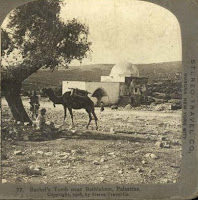
Rachel's Tomb (1908) (Credit: Omaha
Public Library)
Students from the Gymnasia visiting Rachel's Tomb. Presumably, the school is
the Gymnasia HaIvrit Herzliya, the first Hebrew high school in Palestine, founded
in 1905. (Credit: Wikimedia Commons, circa early 20th Century)
Aerial photograph of Rachel's Tomb (1931) 
British (Scot) soldiers stopping Arab in
weapons search, Rachel's Tomb 1936In October 2010, UNESCO declared that the holy site was also the Bilal bin Rabah mosque and objected to Israeli "unilateral actions" at the shrine. Bilal bin Rabah was Mohammed's Ethiopian slave and muzzein who died and was buried in Damascus. The claim that the site was a mosque was first made in 1996.
- OCT22
Picture of al-Aqsa Mosque in Jerusalem also Shows Grandeur of the Tiferet Yisrael Synagogue -- Destroyed in 1948
The Library of Congress archives lists this picture as "al-Aqsa," taken by the American Colony photographers sometime between 1898 and 1946.
Al-Aqsa colonnade and a structure on
the right
To be more exact it is the "Colonnade of Omar" located between the al-Aqsa mosque and the Dome of Rock, and it was probably taken in the early 1930s when the American Colony photographers focused their lenses on the rebuilding of the al-Aqsa after its partial destruction in the 1927 earthquake.
But we noticed something else in the picture, the prominent building on the hill to the right of the colonnade.The building is the Tiferet Yisrael Synagogue, also known as the Nissan Beck Synagogue, named for its founder. A Hassidic synagogue in the Old City, it was located near the equally prominent Hurva Synagogue founded by students of the Vilna Gaon who differed with the Hassidic movement on many issues.
Enlargement of the Tiferet Yisrael synagogue
(circa 1930)
Two domes -- The Tiferet Yisrael Synagogue (left) and
the Hurva Synagogue (1900)
The same picture colorized. (George Eastman collection) 
"View of the Old City from the Temple Mount
with the Jewish Quarter in distance." Note the
two synagogue domes (circa 1900)
The synagogues' size, architectural prominence and commanding view were not popular among Muslims in the Old City; even the color of domes was reportedly a target of complaints.
With the outbreak of the 1948 war, the synagogues were used as refuge for the Jewish residents of the Old City as well as military positions for the Jewish defenders. When the Jewish Quarter surrendered to the Jordanian Legion the two synagogues were blown up. The Jewish Quarter and its religious institutions were razed.
British (Scot) soldier guarding the Jewish Quarter
and the Tiferet Yisrael synagogue in 1948,
prior to the end of the British Mandate.
(Source: Life Magazine archives)
The destroyed Tiferet Yisrael synagogue and a Jordanian
soldier. (Source: Wikipedia, 1948)
After the Israel Defense Forces captured the Old City in 1967, the Jewish Quarter and the Hurva synagogue were rebuilt. The Tiferet Yisrael Synagogue has yet to be rebuilt.
For more information on the Old City synagogues, click here and here for earlier photo essays.
Click on pictures to enlarge. Click on the link below the picture to view the original.
Subscribe to www.israeldailypicture.com to receive every photo essay by email. Enter your name in the box in the right sidebar to subscribe.0Add a comment
- OCT19
A Cave under the Temple Mount's Foundation Stone? More Mysteries Documented in Ancient Pictures
For centuries, the Temple Mount in Jerusalem has been the focus of worshippers, scholars and explorers.
Descent under the "great rock" on Mt. Moriah (under the Dome of the Rock).
Woodcut in explorer Col Charles Wilson's book, Picturesque Palestine, Sinai
and Egypt. (1881, New York Public Library)
But few archaeologists have explored history's secrets hidden in the caves, tunnels and cisterns beneath the Hiram el-Sharif -- controlled by the MuslimWaqf.
The Israel Daily Picture site provided last week photos from the Library of Congress archives taken after a 1927 earthquake destroyed parts of the el-Aqsa mosque.
Interior of Mosque of Omar (Dome of the Rock) and the
Foundation Stone. (circa 1870, Bonfils, Library of Congress)
See also photo from American Colony Collection (circa 1900).
According to Jewish tradition the stone was the site for Abraham's
"binding of Isaac" and the location of the Temples' Holy of Holies.
Muslims believe it was from where Muhammad ascended to heaven.We were very curious when we discovered additional photos in the American Colony and Felix Bonfils collections showing the entrance to a cave beneath the "foundation stone" (even hashtiya in Jewish tradition) on which the Jewish Temples and the Mosque of Omar* were built.
The Temple Institute in Jerusalem provided details on the cave:
Beneath the rock is a hewn cave [some claim the cave is natural] seven-by-seven meters wide. In the cave's ceiling is a hole approximately half-a-meter in diameter, a sort of chimney going up.
Entrance to the staircase to the cave beneath the Foundation
Stone (Bonfils, circa 1870). See also American Colony photo
"Solomon's Prayer Place" can be
seen in the above woodcut to
the left of the staircaseA feature inNational Geographic suggested that the beneath the cave may be another chamber hiding the Ark of the Covenant: "Knocking on the floor of the cave under the Muslim Dome of the Rock shrine elicits a resounding hollow echo, [but] no one has ever seen this alleged chamber....Famed 19th-century British explorers Charles Wilson and Sir Charles Warren could neither prove nor disprove the existence of a hollow chamber below the cave. They believed the sound reportedly heard by visitors was simply an echo in a small fissure beneath the floor."
The cave under the Foundation Stone today (with permission
of Ron Peled, All About Jerusalem)The American Colony photos include a picture taken in the cave captioned "Solomon's prayer place under rock of Mosque of Omar [i.e., Dome of the Rock]." The prayer niche is more likely an ancient Muslim Mihrabpointing to Mecca.
*According to National Geographic, "the dome, called Qubbat as-Sakhrah in Arabic, is not a mosque. Rather, it is a shrine built over the rock."2View comments
This summer the Yisrael HaYom newspaper reported on archaeological artifacts found by a British scholar after part of the el-Aqsa mosque collapsed in the 1927 earthquake that struck Palestine. Reporter Nadav Shragai revealed that items from the period of the Second Jewish Temple were found but that their publication was suppressed.
"Hulda Gates" on the southern side of Jerusalem's Old City. The picture
shows the sealed "Triple Gate" (circa 1900)
"Robert Hamilton, the director of the antiquities department during the Mandatory period in pre-state Israel, reach[ed] an agreement with the [Islamic] waqf that would allow archaeological investigation on the Temple Mount, for the first time ever, in the area where the mosque had collapsed."
"In the book that Hamilton later published, he makes no mention of any findings that the Muslims would have found inconvenient. It was no coincidence that these findings came from two historical periods that preceded the Muslim period in Jerusalem: the Second Temple era and the Byzantine era."
Remnant of the sealed "Double Gate" of
"Hulda Gates." Above the gate's lintel are
stones from Hadrian's temple to Jupiter,
destroyed by Constantine in 400 CE and
re-used by the Arabs to build al-Aqsa.
One stone is an inscription stone honoring
Hadrian who crushed the Bar-Kochba
revolt in 135 CE and plowed over the
Temple Mount"Beneath the floor of Al-Aqsa mosque, which had collapsed in the earthquake, Hamilton discovered the remains of a Jewish mikveh [ritual pool used for purification] that dated back to the Second Temple era. Apparently, Jews immersed in this mikveh before entering the Temple grounds."Now we can understand other pictures in the Library of Congress collectionThe collection includes two inexplicable pictures dated between 1920 and 1933 entitled "Ancient entrance to Temple beneath el-Aksa." The pictures were taken on the other side of the Hulda Gates, one of the major entrances to the Temple by pilgrims coming from the vast Shiloah (Silwan) pool. According to the Mishna, the gates were used for entering and exiting the Temple complex.Clearly, the American Colony photographers entered the sacred area, like Hamilton, after the earthquake destroyed parts of the mosque in 1927 to take these rare photos. Otherwise, the area would have been off-limits.
Original caption: "The Temple area. The Double Gate.
Ancient entrance to Temple beneath el Aqsa." Note the
staircase that apparently led to the surface and the
Temple plaza.
Original caption: "The Temple area. The Double Gate.
Ancient entrance showing details of carving."
The Hulda Gates date back to King Herod's Second Temple period, perhaps even to Hasmonean times. According to some commentaries, "Hulda" was a prophetess during the First Temple who apparently prophesized around the area where the gates were built (See Kings II, 22:14).
The Library of Congess collection also includes several pictures showing the extent of the damage to the al-Aqsa mosque in the earthquake.

Al Aqsa Mosque, partly under repair after the earthquake 
Al Aqsa Mosque without roof, "open to wind
and weather" (circa 1934)3View comments
- OCT2
Young Jewish Men and Women Are "Recruited" in 1939 in Response to British Restrictions on Immigration to Palestine
The British "White Paper" approved by the House of Commons on May 23, 1939 severely restricted Jewish immigration into Eretz Yisraelprecisely when the Jews of Europe were under threat of annihilation by the Nazis. The British were reacting to three years of the Arab Revolt which demanded an end to Jewish immigration.
Young women outside of a "recruiting office" during the 1939
protests against the White Paper. The women on the right are
identified as "revisionists" or "brownshirts."
One year ago we featured an essay and photographs taken by the American Colony Photographic Department of the thousands of Jews who poured out into the Jerusalem streets to protest the British policy. Similar demonstrations took place in Tel Aviv and Haifa.
Anti-White Paper demonstration outside
of Jerusalem's Yeshurun Synagogue.
Procession led by Chief Rabbi Isaac
Herzog (in top hat).
Recruits signing up and here
Along the route of the demonstrations, "census stations" were set up to recruit young Jewish men and women, and the Library of Congress collection contains pictures of the recruitment campaign.According to one newspaper account at the time, "All men and women between the ages of 18 and 35 have been asked to voluntarily register and place themselves at the disposal of the Jewish authorities for any duties in order to defeat the new policy."
Recruiting station at the Jerusalem Egged bus station. The sign on
the left reads "census station."
Presumably, they would later serve in the Jewish militias such as the Haganah or Irgun, and many would join the British army to fight the Nazis in Europe and North Africa. An estimated 30,000 Jews of Palestine fought in the British Army in World War II.
Coincidentally, as the White Paper was issued, 937 Jewish passengers were sailing on the SS St. Louis from the German port of Hamburg seeking refuge in Cuba and the United States. Entry was denied. The ship and its passengers were forced to return to Europe because the gates to Palestine were also shut.
One newspaper provided an account of Lithuanian Jews in Kaunas delivering a protest against the White Paper to the British legation and the Lithuanian Foreign Ministry. Tragically, the Lithuanian Jewish community was wiped out by the Nazis.1View comments
- SEP30
How a Family Celebrated Sukkot in Samarkand in 1870; Is This the Same Family in Jerusalem in 1900?
Israel Daily Picture usually focuses on the Library of Congress' American Colony collection of 22,000 photos. But while exploring the Library's archives we came across an amazing collection of pictures of the Bukhari Jewish community of Samarkand in 1870.
Jews sitting in their Samarkand Sukka (circa 1870) 
Another view of the Sukka with the side walls closed (1870)
View more pictures and a history of the Samarkand Jews here.
Members of the community began moving to Eretz Yisrael, the Holy Land, in the mid-1800. They established a new neighborhood outside of Jerusalem's Old City walls.
View pictures of the Bukhari Quarter here.
The American Colony photographers recorded how various Jewish communities celebrated Sukkot in Jerusalem in the early 1900s with pictures of Yemenite, Ashkenazi and Bukhari sukkot booths.
Bukharan family in their Jerusalem sukka (circa 1900). Note
the man on the right holding the citron and palm branch
View the collection of Jerusalem celebrations of Sukkot here.
Is it possible that the family photographed in Samarkand in 1870 may be the same family photographed in Jerusalem in 1900?
Bukharan family in their Jerusalem Sukka
Click on a picture to enlarge.
Click on the caption to view the original photo.0Add a comment
- SEP20
Yom Kippur 100 Years Ago -- Or More: Photographic Treasures from the Library of Congress from Jerusalem, New York and a French Battlefield

Jews at the Kotel on Yom Kippur (circa 1904) See analysis of
the graffiti on the wall for dating this picture. The graffiti on
the Wall are memorial notices (not as one reader suggested
applied to the photo later).Next week Jews around the world will commemorate Yom Kippur, the Day of Atonement. For many Jews in the Land of Israel over the centuries the day meant praying at the Western Wall, the remnant of King Herod's retaining wall of the Temple complex destroyed in 70 AD.
We present here an update to last year's Yom Kippur posting.Several readers commented on the intermingling of men and women in these historic pictures.It was not by choice.The Turkish and British rulers of Jerusalem imposed restrictions on the Jewish worshippers, prohibiting chairs, forbidding screens to divide the men and women, and even banning the blowing of the shofar at the end of the Yom Kippur service.View this video, Echoes of a Shofar, to see the story of young men who defied British authorities between 1930 and 1947 and blew the shofar at the Kotel.

Another view of the Western Wall on Yom Kippur. Note the
various groups of worshippers: The Ashkenazic Hassidim wearing
the fur shtreimel hats in the foreground, the Sephardic Jews
wearing the fezzes in the center, and the women in the back
wearing white shawls. (circa 1904)For the 19 years that Jordan administered the Old City, 1948-1967, no Jews were permitted to pray at the Kotel. The Library of Congress collection contains many pictures of Jewish worshippers at the Western Wall over the last 150 years.
After the 1967 war, the Western Wall plaza was enlarged and large areas of King Herod's wall have been exposed. Archaeologists have also uncovered major subterranean tunnels -- hundreds of meters long -- that are now open to visitors to Jerusalem.Receive a Daily Picture by subscribing in the right sidebar and clicking "submit."Click on the photos to enlarge.Click on the captions to see the originals.Photos of Yom Kippur in New York 105 Years AgoThe Library of Congress Archives also contain historic photos of Jewish celebration of the High Holidays in New York. Some of them were posted here before Rosh Hashanna. Here are two more:
Original caption: Men and boys standing in
front of synagogue on Yom Kippur (Bain
News Service, circa 1907)

Worshippers in front of synagogue (Bain
News Service, 1907)
And a Picture of Jews in the Prussian Army Worshipping on Yom Kippur 140 Years Ago We were a little surprised to find this picture of a lithograph in the Library of Congress archives. The caption reads, "Service on the Day of Atonement by the Israelite soldiers of the Army before Metz 1870." No other information is provided.Kestenbaum & Company, an auctioneer in Judaica, describes the lithograph in their catalogue:
This lithograph depicts the Kol Nidre service performed on Yom Kippur 1870 for Jewish soldiers in the Prussian army stationed near Metz (Alsace region) during the Franco-Prussian War of 1870-71.
Rabbi W. Gunther Plaut, a scholar and Reform Jewish leader who passed away at age 99 earlier this year, provided more facts about the picture. In fact, he called it a "fraud."
The Germans had occupied Metz by August of 1870, however were unable to capture the town's formidable fortress, where the remaining French troops had sought refuge. During the siege, Yom Kippur was marked while hostilities still continued, as depicted in the lithograph.In Eight Decades: The Selected Writings of W. Gunther Plaut. In a chapter entitled "The Yom Kippur that Never Was, A Pious Pictoral Fraud" he wrote:Of all the things in my grandfather's house, I remember most vividly a large print. It was entitled "Service on the Day of Atonement by the Israelite soldiers before Metz 1870." Later I was to learn that this print hung in many Jewish homes.... It was reproduced on postcards, on cloth, and on silk scarves. The basic theme was the same: in an open field before Metz, hundreds of Jewish soldiers were shown at prayer.
Rabbi Plaut cites a participant in the service who reported:
A considerable difficulty arose in relation to the place for the services. Open air services were deemed impossible for Tuesday night because of the darkness and were ruled out for Wednesday because of the obvious reasons [it was a battlefield].... My immediate neighbour was willing to grant me the use of his room so that the service took place in our two adjoining rooms.
Another participant in the unusual Yom Kippur service reported, according to Plaut:Of the 71 Jewish soldiers in the Corps some 60 had appeared. Amongst them were several physicians, a few members of the military government, all of them joyously moved to celebrate Yom Kippur. The place of prayer consisted of two small rooms.
2View comments
- SEP13
Beneath the Old City of Jerusalem Lies a Huge Cave. Does It Date Back To King Solomon or King Zedekiah?
Beneath the Old City of Jerusalem, not far from the Damascus Gate, is the entrance to an enormous cavern, one of the largest man-made caves in Israel. The American Colony photographers visited the cavern 100 years ago.
Five men in "Solomon's Quarry," circa 1910. Another picture
of the group can be found here
From the cave's entrance to the end is 300 meters; its width is 100 meters, and its height in some parts is 15 meters tall. The total size is estimated to be five acres.
And the cavern, which was used to quarry limestone blocks, dates back 3,000 years.
Solomon's Quarry tourists (circa 1910)
According to legend, King Solomon may have taken blocks from the cave to build the First Temple (circa 950 BCE). While archaeologists are sceptical, there is little doubt that King Herod (circa 50 BCE) quarried stone for building his massive expansion of the Second Temple, including what we call today the Western Wall.

"Hanging pillar" in Solomon's
Quarry (circa 1910)
Another legend claims that King Zedekiah of Judah (circa 586 BCE) fled from the Babylonian conquerors through the cave. Talmudic literature dating back to the 2nd - 3rd century CE refers to Zedekiah's Cave.
The quarry was used throughout the Middle Ages, but it was sealed in the 16th century by Suleiman the Magnificent to prevent enemy infiltration under the Old City.
Open & Shut, Open & Shut...
The cave remained sealed and undiscovered until 1854 when, according to another legend, missionary Dr. J. T. Barclay was walking his dog outside of Damascus Gate. The dog ran down a hole that had been opened after heavy rains. Barclay followed him in and discovered the massive cavern.
In the 1880s a German cult took over the cave until they were removed by Turkish authorities. In 1893 the Turks sealed the entrance once again.
Entrance to Solomon's Quarry
(circa 1900)To secure stones for a clock tower the Turks were building at Jaffa Gate they reopened the quarry in 1907. Presumably, the American Colony photos are from that period because the cave was sealed again in 1914 during World War I. 
Ad: "Entrance to Zedekiah's Cave
From now residents of Jerusalem will
pay 3 grush per person. Groups of 10
pay 25 ..."An advertisement announcing tours and admission rates to the Cave appeared in a Hebrew paperHatzvi during this period, in April 1909.
During the British Mandate Zedekiah's Cave was reopened and actually converted to a bomb shelter during World War II. The cavern was closed again in 1948 by the Jordanian authorities because of its location along the Jordan-Israel armistice line.
The Quarry as a bomb shelter (1940s)
In 1967, after the reunification of Jerusalem, Israel reopened the cavern.
Read this excellent description of the cave written by Thomas Friedman when he was serving as The New York Times' Jerusalem bureau chief in 1985.3View comments
-
"Blow the Shofar at the New Moon...Because It Is a Decree for Israel, a Judgment Day for the God of Jacob" - Psalms 81
Yemenite Jew blowing the shofar (circa 1935)
Jews around the world prepare for Rosh Hashanna next week, the festive New Year holiday when the shofar -- ram's horn -- is blown in synagogues.
The American Colony photographers recorded a dozen pictures of Jewish elders blowing the shofar in Jerusalem some 80 years ago. The horn was also blown in Jerusalem to announce the commencement of the Sabbath. During the month prior to Rosh Hashana, the shofar was blown at daily morning prayers to encourage piety before the High Holidays. 
Ashkenazi Jew blowing the shofar to announce the Sabbath 
Yemenite Rabbi Avram, donning tfillin for his
daily prayers, blowing the shofar
View the American Colony Photographers' collection of shofars in Jerusalem here.
Click on the pictures to enlarge.Click on captions to view the original picture.Receive Israel Daily Picture on your computer or iPhone by subscribing. Just enter your email in the box in the right sidebar of the Internet site www.israeldailypicture.com2View comments
Tuesday, August 18, 2015
Rachel's Tomb -- We Present a Special Album of Pictures to Commemorate the Death of the Matriarch Rachel about 3,600 Years Ago - picture a say


Subscribe to:
Post Comments (Atom)
View comments