In the early 1900s, the British Empire relied on the Suez Canal to maintain communications and trade with India, Australia and New Zealand. And that was precisely why Germany encouraged Turkey to challenge British rule over Egypt and British control of the Suez Canal.
Gaza after the two battles in March and April 1917.

Turks prepare to attack the Suez
Canal, 1915
In early 1915, the Turkish army in Palestine crossed the Sinai and attacked British troops along the Suez.
The British army beat back the attacks, took the war north into Sinai and pushed the Turkish army back to a defense line stretching from Gaza, located on the Mediterranean, to Be'er Sheva, some 40 miles inland.
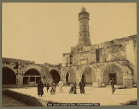
Great Mosque of Gaza (circa 1880)
In March and April 1917 the British army attempted to push through Gaza in battles that involved as many as 60,000 soldiers, British and French ships firing on Gaza from the Mediterranean, the use of poison gas, and the deployment of newly developed British tanks. The British suffered a disastrous defeat.
The Mosque after the fighting (1917)

Ruins of Gaza, believed to be after the 1917 battles

British trenches in Gaza. After the
defeat, the British army switched to more
mobile tactics.

British tanks destroyed in the Gaza fighting
The British campaign for Jerusalem would be stalled for six months. It would be led by a new commander, a large number of reinforcements, and a new strategy that took the war in a new direction, east toward Be'er Sheva.

British Prisoners of War,
captured in Gaza 1917
Appearing soon: The Battle for Be'er Sheva, October 31, 1917
Footnote: History records Jews living in Gaza for thousands of years. [View the mosaic depicting King David from a 6th century synagogue in Gaza.]
Ottoman tax records showed dozens of Jewish families in Gaza in the Middle Ages. One of the most famous Gazan Jews was Rabbi Israel Ben Moses Najara (16th Century) who composed prayers and Sabbath zmirot (songs) popular to this day. He was buried in Gaza.
Mosaic of King David
(Israel Museum)
Jewish families fled Gaza in the 1929 pogroms. Population records still showed Jews living in Gaza until 1945.
Kfar Darom, named for a community mentioned in the Talmud, was a Jewish kibbutz established in the Gaza Strip in 1930 that was abandoned in the 1948 war. Kfar Darom was reestablished in 1970 but evacuated by Israel in the 2005 "disengagement."
Be'er Sheva (circa 1900). See also here For centuries, Be’er Sheva was little more than a desert oasis surrounded by scattered Bedouin tribes. In the 19th century the Ottoman Empire established a garrison in the village (“town” would be an exaggeration), and as war clouds gathered in the early 1900s, the Turkish army presence grew.
Be'er Sheva well (circa 1900). See
also hereThe American Colony photographers recorded scenes of the town, showing it sparsely populated and almost barren.
Army tailors 1917. See boot-makers here The photographers took pictures of some of the services that were established for the army – a tailor shop for uniforms, cobblers for the army boots, a mill for flour, etc.
Be'er Sheva, 1917, on the eve of the war. Note the army
encampment on the right. Click to view the serai, or inn.The present day Be’er Sheva municipality reported that Jews arrived in Be’er Sheva during this period to work in some of these services and to work on the railroad line and bridges to Be’er Sheva.The largest building in Be’er Sheva was the serai, an inn. The wells of Be’er Sheva were the only source of water in the region.
The arrival of the first train in Be'er Sheva, 1917. Note the large
contingent of soldiers. Turkish railroad lines were built
throughout Palestine to support the war effort.During World War I, Be’er Sheva was a supply center for the Turkish army and an anchor for Turkish-German defense line between Gaza and Be’er Sheva blocking the British army’s advance north from Sinai. The British attempted to break through the line at Gaza twice in March and April 1917, and they failed disastrously, losing thousands of men.Watch for these two features here in coming days: The Battles for Gaza and The Battle for Be’er Sheva, October 31, 1917Click on the photos to enlarge. Click on the captions to see the originals.

Aerial photo, Be'er Sheva, 1917. (Source Australian Light Horse
Studies Centre.) Note army tents located around the village.
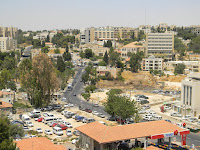
Be'er Sheva today. (Source The Marker)
population 200,000.1
View comments
The Ottoman Empire established a postal service throughout Palestine in the 1800s, but six foreign powers had contracts -- called capitulations -- which permitted them to run their own postal service.
A stamp showing
Rachel's Tomb with
writing in English,
Arabic and Hebrew
After Great Britain captured Palestine from the Turkish army in late 1917 and 1918, it set about to establish one local Palestinian Mandate postal service.
Printing and proofreading stamps 1920
In 1920, the British supervised the printing of stamps, and as an "overprinting," added Hebrew to the Arabic and English on the stamps.

The "overprinting" in English, Arabic
and Hebrew
The Jews of Palestine requested that the name Eretz Yisrael be printed on the stamps in Hebrew. The Arabs protested, and the name Palestina was written in Hebrew with an important addition: the letters Alef and Yud were added -- the abbreviation of Eretz Yisrael.
Proofreading the stamps, 1920 7
View comments
- Originally published in July

The Jaffa Gate of Jerusalem's Old City faces west to Jaffa. Just head out on Jaffa Road. The Jericho Road heads east, and the Hebron Road leads south. Damascus Gate, called Sha'ar Shchem (Nablus Gate), faces north.
Nablus Road plays a prominent role in the Library of Congress-Matson collection, perhaps because Eric Matson's American Colony community was located along Nablus Road.

The Photographer cuts off left part of photo, adds caption.
The first photo (1) shows the state visit to Jerusalem of Kaiser Wilhelm II of Germany in 1898. The royal party entered the city from the north, passing the American Colony building. New photo added: Photographer's own caption, "The Kaiser Passing our House," but it's missing several elements on the left of the picture.

1. Kaiser Wilhelm of Germany (on
the white horse) entering
Jerusalem on Nablus Road. 1898.
Note the Jewish bystander
and the minaret on the left.
Note the minaret on the left of the Kaiser; it shows up in this second photo (2) of the Turkish army heading south on Nablus Road.

2. Turkish soldiers marching
south (circa1900)
The third photo (3) is undated but is certainly prior to 1911 when a tower on the Italian Hospital showed up on Jerusalem's skyline. It doesn't appear in this photo.

3. First view of Jerusalem from
the North
Click on a picture to enlarge. Click on caption to view original.
After World War I and Britain assumed contol of Palestine, Nablus Road and the route north were important for maintaining control of Palestine, particularly during the Arab Revolt (1936-1939). Picture 4 shows British armored vehicles providing protection to a convoy traveling between Jerusalem and Afula in 1936.
4. British convoy from Jerusalem
heading north 1936
New pictures added October 22, 2011
The American Colony's location adjacent to Nablus Road provided its photographers a vantage point on history. Picture 5 shows heavy British artillery being moved south on Nablus Road in 1917 or 1918. Picture 6 is a picture of Jewish children marching on Nablus Road in 1918. (An essay about the picture appears here.) Picture 7 shows British soldiers heading north responding to Arab riots in 1920.

7. British Soldiers heading north
past the mosque in response
to Arab rioting, 1920. Note the
Indian soldiers.

5. British artillery heading
south through Jerusalem
on Nablus Road. 1917-1918.
Note house with arches.
6. Jewish children marching south
on Nablus Road in 1918. Note
the house with the arches and
the British army camp on the
hill on the left. An essay about
this picture appears here
For comparison we also present an aerial photograph of Nablus Road in the 1930s and a contemporary picture of Nablus Road.

Aerial photograph of Nablus Road 1931. The house with
the arches had a second story added. Today it is a school.
Nablus Road today. Note the house
with the arches. The mosque complex is
on the right.0
Add a comment
The caption on this Library of Congress photograph reads, "Children's group at WIZO summer beach house for poor children of Khadera."
Feeding the poor children of Hadera (circa 1935)
WIZO is the Women's International Zionist Organization, founded in Great Britain in 1920 to help build the Jewish national home and to assist women of Eretz Yisrael through education and training.

Children's home in Heftziba
west of Hadera
Hadera, south of Haifa, was built on swamplands purchased in 1890 from an Arab Christian from Lebanon, Salim Khoury, who was a major landowner in Palestine. A year later, Jews originally from Kovno, Riga and Vilna arrived to dry the swamps and settle in the area.
Another photo (left) reveals a little more information about the children's home located in the "Heftziba settlement on the coast west of Hadera."
The Heftziba farming settlement began in 1906, but encountered severe hardships -- a plague of locusts in 1915, forced conscription of its workers into the Turkish army during World War I, and financial debts. By 1929, the farm and orchards were largely abandoned. Some of the workers of the farm established a kibbutz near Mount Gilboa in northern Israel in 1922 and named it "Heftziba."
Olive grove stripped of all leaves
after locust plague, Spring 1915
The photographers of the American Colony Photographic Department recorded dozens of pictures of the 1915 locust plague, available in the Library of Congress collection.
Today, Jews around the world commemorate the last days of the Succot holiday. Today is called Hoshanna Rabba, and one of the special prayers in today's liturgy asks for salvation from various agricultural blights including the plague of locusts.1
View comments
Tuesday, August 18, 2015
Library of Congress Photos Show the British Army's Failure to Take Gaza in 1917, Delaying the Capture of Jerusalem - picture a day


Subscribe to:
Post Comments (Atom)
Add a comment